
I've never been to Wyoming, and I hadn't put too much thought into it. Last Thanksgiving, at our annual Joshua Tree National Park potluck, my friend Tara began conspiring a climb in the Grand Teton National Park. We spent months deliberating about who / what / when and how it could be done. I flaked on some important people and some important people flaked on me. There is some honest chagrin in my heart how the plans unfolded, but we lacked synergy in experience. The details devolved and evolved over nine months and didn't settle until seven days before pushing off, but I want to acknowledge Tara for raising my eyebrow to a National Park that I knew little to nothing about, and left with many stones still unturned.
On Thursday August 3rd, 2017 I left Burbank at 3:30am to pick up Taco and we began our arduous drive to Wyoming. We stopped briefly in Salt Lake City, ate tons of fast food, listened to endless podcasts, and dinned on a comedic prime rib dinner at a place called Dad's. We landed at our motel, Snider's Rustic Inn, in Thayne, Wyoming around 9pm. We needed to pick up our backcountry permits between 8am and 10am at the Grand Teton National Park ranger station the next morning or we would risk forfeiting them. Thayne is 90 minutes outside of the park. This gave us time to get a functional night's rest, wake up at a reasonable hour, get our permit and begin our approach to the climb.
Upon first gaze, one is consumed by these mountains. Unlike the Sierras, there are no foothills, so the peaks are highly dramatic, just shooting upwards and looking very intimidating. In the photo below the Grand Teton is the most obvious, acute triangular shaped mountain in the middle of the frame. It is the highest peak in the Teton range (a subrange of the Rocky Mountains), standing at 13, 775' above sea level. Summiting the Grand Teton is listed an one of the Fifty Classic Climbs of North America.
We picked up our backcountry camping permits at 9am at the Jenny Lake Ranger station. The plan was to haul in a ton of supplies so we could spend several nights on the mountain, this would create a cushion to catch a good weather window for a safe ascent.
We got to a very crowded parking lot Friday morning and began our hike at the Lupine Meadows Trailhead with a casual start of 10:30am.
The first four miles of trail are beautiful. Wild flowers blooming, expansive views of lakes inside the park, a gentle graded trail. An excellent beginning.
Seen below is a photo of Taco and I when we rounded a corner and first set eyes on Garnet Canyon, this was our first personal hint at what we'd have in store. You can tell by our expressions that we still had some innocence and enthusiasm about the objective.
The hike to our assigned base camp, at the Lower Saddle, is 7 miles from the Lupine Meadows Trailhead, which isn't bad, but contains 5,000' of vertical gain, which is really intense. Lots of switch backs when we entered Garnet Canyon proper.
Below is a photo of me just underneath Spalding Falls. Notice how huge my pack is. We hauled up quite a bit of food, all our shelter supplies, clothing systems, and of course the heaviest provision, our climbing ropes and rock protection, I'm guessing upwards of 45+ pounds.
On the bright side there is water everywhere. I never carried more than one liter at a time. There are snow melt streams all over the place, and once above 10,000' we never bothered to filter it. The water was delicious and safe to drink in my opinion (and the ranger's personal opinion).
Above Spalding Falls are some of the most difficult switch backs, but don't worry, because after that it gets worse. You then enter the moraine, which is a boulder slog of combined talus, scree, and the occasional loose dirt path. We just chugged foward. Towards the top of the moraine is a short section of 3rd / 4th class, that acts as a bit of a summit headwall to get to the Lower Saddle. There is a large fixed rope to yard on so you don't fall (which could yield serious consequence).
I believe it took us 8.5 hours to hike from the car to our base camp at the Lower Saddle. We moved less than one mile per hour. Our heavy packs were perhaps our biggest regret, but you live and learn. It was wild on the mountain, we got there at 7pm and it didn't get dark until around 9:45pm. We had plenty of time to set up our little tent and cook dinner.
After dinner we wandered around the lower saddle with excitement. The guiding company has an enormous permanent shelter up there, and many clients are working on last minute rope skills. There is also a National Park Climbing Ranger shelter that sits behind the guide's hut (middle right side in photo below). We camped at a distance from the crowds but chatted briefly with many of them. There was a nice camaraderie present.
We watched the sunset over the Teton Range and were able to get some cell service at a specific camp location. This allowed me to check a last minute weather forecast and send safety confirmations to my wife.
Still all smiles, we stared at tomorrow's goal. Behind Taco in the photo below, we got a much better view of the technical part of the Grand Teton. We would loosely follow the red arrows up that scree, over the Exum Gully and up the Exum Ridge, with the summit just out of frame.
Considered to be one of the largest cruxes of the Upper Exum ridge is the exercise of actually finding the beginning of the route. One must locate "Wall Street" pictured below. Wall Street is a large ledge system, wider than a sidewalk. From our campsite it took 2.5 hours to get here. You head up the ledge until it thins out at the end. From here people rope up and belay around an extremely exposed corner. On the corner it drops off a couple thousand feet below, and although it is quite airy, it wasn't too difficult.
I belayed taco around the corner but watching him opt not to place any protection before the step, I took him off belay. He just soloed around the way and then coiled the rope and belayed me across it. Immediately on the other side of the corner is the Golden Stair pitch, we are now on the Upper Exum Ridge proper and the only way from here is up!
Taco quickly lead the Golden Stair pitch after the step over. It's quite knobby and easy ground, but lacks some decent protection. It's a good way to get going. After that pitch there was some scrambling and I started to lead up the Wind Tunnels, more easy ground. A little meandering so we placed sparse pro, sometimes none at all.
From the top of the Wind Tunnels you reach the Friction Pitch, this is often noted as the crux of the climbing. The section looked quite featured, but it was very polished and slippery, little to no hands for balance, and extremely run out for protection, so naturally I had Taco lead this! He crushed it and ran up with no problem. He belayed me up, and I was quite surprised how challenging it was for the mellow grade and how deceiving it climbed vs. how it looked. I was wearing approach shoes and I don't think that helped with the details of this footwork.
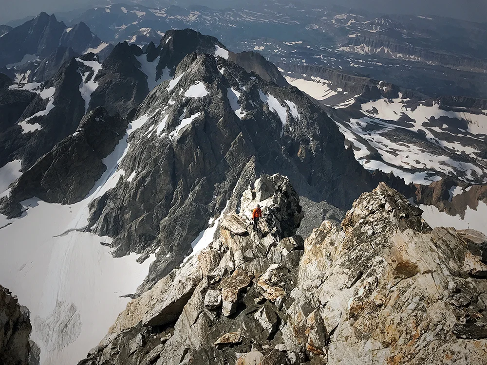
Ridge routes like these are challenging to look back at, you can't always remember exactly which part is what. Also, there were only two of us, so shooting photos, while either climbing or belaying, is never simple. However, I think the photo below is an excellent example of the dramatic aesthetic on the Grand Teton's Upper Exum Ridge. I suspect Taco shot this photo of me from somewhere above the Friction Pitch.
After the Friction Pitch we split leads on the Notch Gully and arrived at the V-pitch. I lead the V-pitch (also called the Open Book Pitch). I had some good anticipation for this and put on my actual climbing shoes. I can guess we were at around 13,000' above sea level. The pitch takes protection well and I started to lead confidently, getting in some small gear.
I got to the crux and started jamming and side pulling when I should have been lay backing. It was exciting, and while I geeked a little for abandoning my techniques, I pulled through.
Below is a photo of me above the V-pitch, belaying Taco up. A proud moment for me as I am cutting my teeth in alpinism. Even when the climbing moves are easy, at this altitude you must stay focused.
Below is Taco at the crux doing the correct lay back technique. What a show off!
Check out that exposure, nice.
I was under some impression that after the V-pitch the thing was kind of over. To my surprise we had a fair amount of climbing left, and some of the most difficult terrain that day. Maybe we under estimated, but we thought it would be clever to simul-climb the rest of the route, and lacking any kiwi coil, we just stretched the full 60 meters of our rope. I would say we were pretty casual about it.
Taco heading over a really exposed notch, and up a steep ramp, then out of sight and just starting to run the rope.
We arrived at the "Boulder Problem in the Sky" which is in fact quite boulder-ey. It's a short problem, but required some commitment and thought. In hind sight we both agreed it was the hardest climbing move of the entire ridge route.
I think after simul climbing the boulder problem my nerves were pretty shot. Taco lead the last few hundred feet over a ridge walk, which are naturally difficult to protect. I had a hilarious moment attempting some selfies and dropped my phone, so lucky it didn't fall off the mountain! The altitude was kicking our butts and the summit seemed to always be "around the next corner."
1:30pm and we made it. Took us 7 hours from camp to the summit, or 4.5 hours from Wall Street to the top. We were excited! There were a few others at the summit who came up the Owen Spalding route and everyone was celebrating. The weather was great, not crazy windy, but warm. We were at nearly 14k feet above sea level in t-shirts.
When Taco and I first met we climbed Snake Dike on Half Dome in Yosemite and at the top we ended up taking this really awkward summit pose. I think it was partly because we didn't really know each other and partly I was pulling him near the edge of the cliff. The photo became a bit of a running joke, so we posed for an exaggerated recreation. Next time we will actually be on two different mountains.
We spent a fair amount of time at the summit. Making jokes, talking to people about their experiences on the different routes they took to the top, using our cell phones (full bars!), taking photos and doing a little vogue modeling.
I was surprised, and saddened, there was no summit registry box at the top. The only mark is the US Geological Survey emblem installed on a rock, so one must naturally photograph it. 13,775' above sea level!
On a really awesome side note, I had a moment to mix business with pleasure. I designed some Grand Teton National Park apparel graphics for Los Angeles based clothing company Parks Project. I wore it on the climb and was thrilled to represent on the summit of the parks biggest icon. You can purchase this hat directly from Parks Project HERE. The t-shirt is available from BackCountry.com HERE. Also it was amazing to see some my graphic design in the official park visitor center and ranger stations, not the cheesy souvenir grocery stores, those official products put money directly back into the park. SUPPORT!
We hung out at the top for about 30 minutes until 2pm and then it was time for the second half of the climb, GETTING DOWN.
The standard descent is using the Owen Spalding route, an easier classic often used by the guide services to obtain the summit with their clients. The descent involves lots of hiking down steep and loose dirt, much down scrambling and a couple rappels.
Just below the summit I ran into my good friend Josh of TUFA CLIMBING, purveyor of the most intelligent chalk bags and summit packs. Check out his work HERE.
We had planned to tag along the ascent together, but still had a blast hiking down and camping the rest of the weekend. When Josh and I met in April last year, we were on the Monkey Face in Smith Rock, what icon will be next?!?
There was a traffic jam at the second (longer) rappel where we hung out and chatted with more people. We tied our rope together with some strangers from Idaho to make the descent faster. They were really cool locals. One of the guys worked in the park for two years and had some good stories. He opened his backpack and had the most comically large tupperware I've ever seen anyone carry on an alpine climb. He gave Taco and I some homemade pasties. It's like an empanada thing with flaky dough on the outside and inside was potatoes and meat from an Elk that he hunted. That was probably the only "real food" we ate while on the mountain. He also told us how his highschool mascot was a potato with a crown and cape, ha!
The second rappel caught me off guard as you dropped down past your vantage point the wall cut out and your free hanging for quite some time down a very exposed view, and of course I started spinning a little. I'm personally not a fan. This also reminded me of the rap off the Monkey Face HERE. After that, more down climbing and at the third rappel of Sargent's Chimney, we down climbed some tricky stuff on exposed terrain instead of using the anchor (thanks Josh and Taco! *eyeroll*).
Eventually we got back to camp at the Lower Saddle, it was around 6pm, making it an 11.5 hour round trip climb. I made Josh a quick cup of coffee and he and Christine hiked back to their car. They hiked in at 3:30am and got back to the trailhead at 11:30pm, so be in great shape if you're not camping! Taco and I were VERY content with spending the night resting at Lower Saddle. We ate a very early dinner and went to sleep at 8pm when it was still light out. We were beat and the altitude, even at base camp, was still taking it's toll on us.
We got up early the next day, reassembled our grossly weighted packs and headed down Garnet Canyon. The worst was descending the fixed line back into the moraine. It's a little sketchy, the bags so heavy pulling you backwards, and it's 6:30 in the morning, not the most pleasurable way to start your day. We took it very slowly and carefully.
After the degradation of the descent back through the moraine and down the steep switch backs around Spalding Falls, I got some hope seeing the lake and the tree line. The 5000' hike down just hammered my toes, and all my other muscles were compounded with the activities from the prior two days. Here I turn into a zombie and just start walking with no breaks, just let your mind wander about eating real food, changing your clothes, procuring a cold drink. This becomes life.
It took us 5.5 hours to get to the trailhead from camp, not terrible. Afterwards we secured a front country campsite in Gros Ventre and met Josh and Christine in Jackson. We ate some lunch, got iced coffee, wandered the gear shops and silly galleries. Lots of people watching on a Sunday in Jackson Hole. At 6pm Taco and I headed to Gun Barrel, a well regarded steak and game restaurant in Jackson. My friend Sam hyped it up and it lived to the hype, thanks SAM!! I had the mixed game platter; Elk Steak, Buffalo Sirloin and Venison Bratwurst with Bison Carpaccio for an appetizer. It was an excellent celebration meal and I narrowly escaped cardiac arrest from all that meat, yeehaw!!
BONUS TRIP REPORT. Monday August 7th, 2017, we woke up in Gros Ventre and packed the car. We drove through the Grand Teton National Park and headed for tourism at Yellowstone National Park. We were thrilled to do lots of sitting, little walking, and lots of looking for a deserved rest day. Yellowstone was crowded but it was a Monday, I can't even fathom what a Saturday would look like. We checked out the geothermal features of the Grand Prismatic Spring, which was spectacular and then headed to see Old Faithful Geyser activate, which was crowded and reminded me of a seeing a Shamu show at Sea World, sort of surreal.
After Old Faithful we immediately started working our way back to Los Angeles. Over all we drove about 2,200 miles to get there and back. It was an incredibly successful mission and a really great summer exploration to a part of the country we had never seen. I would love to go back (on an airplane and not carry a heavy backpack).