
This week's entry was my heaviest trip this year. I remember accomplishing Half Dome via the southwest face and having to hike 10 miles back to the trail head after descending the mountain. When I got back to the car I thought "well I'll NEVER do that again." I thought if anyone asked me to describe the Snake Dike route I would simply reply "it's alot of work." This month we set out for alpine climbing in the high Sierra's and the trip sort of dwarfed Half Dome in my mind.
Let me briefly describe a couple different styles of climbing (in order of difficulty) : 1.) GYM climbing: indoors, on plastic holds- I'm not sure this is actually rock climbing. 2.) SPORT: outdoors, usually in the front country, using preexisiting drilled anchors placed in rock to protect you while you climb. 3.) TRAD aka CLASSIC aka TRADITIONAL: outdoors, could be front of back country, uses active ans passive pieces of protection that you supply (and remove) while climbing. 4.) MULTI-PITCH: outdoors, front/back country, this style if climbing is usually trad, but occasionally sport and requires climbing pitch above pitch to ascend several hundred feet. 5.) ALPINE: outdoors, always back country and always uses trad rock protection, always involves several pitches and essentially ascends a mountain or peak. This is technical mountaineering.
So less than a week after getting home from Florida, and months of eyeing and spying on this particular peak, the date was set. I was able to get a permit too. Permits are not needed to climb, but there are quotas on certain trails in the Sierra Nevada during the busy seasons.
The objective at hand was a very true alpine climb of Bear Creek Spire, a near 14,000' peak in the high Sierra's of Bishop California. The team would be me and the infamous Taco aka Ryan. He's been the best of climber buddy to me this year. We've climbed Half Dome, we've done Tahquitz, some L.A. basin sport and even knocked out a couple first ascents together. Taco also had Bear Creek Spire (BCS) on his "to-do" list.
For the weeks building up to the trip, I have to say, I was very nervous. I have never done any technical climbing at such high altitude and was curious how I'd fair. I have hiked mountains in the high altitude and it's a literally drag above 12,000 +++ feet, climbing would require immense mental focus. To prepare I researched like it was a college final. I read every trip report I could find, googled every photo, bought guide books on the High Sierra's and downloaded USGS maps of the area. All prepped, outlined, printed, folded for pocket size. There would be little room for error on this trip because our attempt would be a "car to car" climb. This means start at the car and return to the car the same day, not an overnight trip. Often alpine climbing is split into multiple days because you have to hike out just to get to the mountain. This particular approach seemed feasible it was only 6 miles and 2,500' gain to the base of the Bear Creek Spire.
I left Los Angeles on Friday night and drive directly from work to pick up Taco, we then drive straight to Bishop to "dirt bag" at the trailhead. This meant getting to Mosquito Flats around midnight and just sleeping outside the car. Mosquito Flats is already at around 10,000' above sea level, even though there's been a heat wave, it was below 40 degrees at night.
With a few crappy hours of sleep we woke up at 5:30am, just as the first sun was peeking. We did a final pack of our back packs and got on the trail around 6am, on schedule.
The approach itself is insanely beautiful, my friend Tara describes it as "best bang for your buck." The area of the Inyo Wilderness is called Little Lakes Valley, and is just lake after lake after lake. An easy trail, great back country camping and backpacking, water everywhere and gorgeous mountains in the background.
Everything started off swell, my mind was in the right place, my heart and spirit were in it to win it. I was hauling a fairly heavy pack, I had alot of food, too much water (didn't need any because there were lakes everywhere), extra winter clothes (for the high altitude), a heavy climber's rope, harness, small first aid kit, tool kit, climbing shoes, and whatever else needed. I would say a solid 35 pound pack, which is heavy for a day pack. This is a weight I would have for an overnight trip, but climbing gear is heavy and Taco was carrying all the rock protection, which isn't light either.
Here is the sun rising over Long Lake. If for no other reason, to see this was purpose enough to get out to Little Lakes Valley and the Mosquito Flats trail.
To be square, I can feel altitude effects above 9,000, and at 10,000 for sure. I was dosing high on ibuprofen from the drive in to prepare, but even the few hours of sleep were not enough to acclimate. Tons of water, 600-800mg of ibuprofen every 6-8 hours would be mandatory. Try and eat too, which is more difficult than you'd imagine.
We hit a junction and headed towards Morgan Pass. Half of the approach was on-trail travel. It was about 2.5 miles to gem lakes, then turn off and another 3.5 miles of cross country travel to the base of the mountain. You can see the route highlighted in pink on the map at the top.
We took a 10 minute break split break at this lake. We were moving slow. A consistent pace but the altitude and heavy packs were not our friends. As we got off the main trail and hit Gem Lakes, the mountains in the background seemed to look closer and closer. Eventually we would be out of the trees and into the stone.
The navigation was fairly simple, of course we probably put in a little extra credit work and gained a few more feet than we needed to, but we made sure to take note of the landform as to take the easiest route back home. The description of our approach read something like "turn off the main trail and head up a steep scree drainage" ayyye seemed to be a wheeee bit of an underwhelming description.
The scree and talus field became a real slog. My intentions were good and my energy was still high. We arrived at Dade Lake, which was a large landmark and sort of the last stop before we would start the actual climb. Dade Lake was pretty, alpine lakes are intriguing. It's rocks everywhere not a tree in sight and then this super blue water. We had hiked 5 miles at this point, and were at an altitude of around 12,500'. We took our longest break of the entire day at Dade Lake. Maybe 40minutes. We had a good sized lunch. We donned our harnesses and helmets and took unfurled our summit bags (small stowable packs). We repacked our climbing bags with just water, snacks, down jackets, and the climbing tools. We left our larger packs at the lake.
At the lake another couple caught up with us. Some married fold who lived in El Portal. He was a professional rock guide, and his wife just an enthusiast. They were climbing the same route as us. So in perspective, a PROFESSIONAL ROCK CLIMBING GUIDE, was going to take his day off to climb the North Arete of Bear Creek Spire, the same thing I was going to do. Except I've never done any true alpine climbing experience like this. Ok. Nice couple, they didn't seem the least tired. They passed us to the base as we finished cleaning up. One mile left.
In the photo above, you can see Dade Lake small in the background. You can see I'm wearing my helmet (which doesn't fit in my little summit pack. Also wearing my harness and have the climbing rope strapped outside my pack for the duration of the last mile. It had become a real labor to get up these 6 miles.
Finally, as we crossed some marble striped slab we could see the first grand view of Bear Creek Spire in all it's glory! it's the obvious triangle shaped mountain in the middle! I was feeling a little intimidated. This is not just rock climbing, this is mountaineering.
We got up to BCS with the married mountain guide party in front of us. Seemed like one more party was in front of them, so we had a tad bit of a traffic jam. We were not over-concerned because we would enjoy the slight break before the next part of the venture. However time is of the essence on a car to car day trip and waiting around wasn't in the cards.
You can see the mass of the task at hand. That red arrow points to a human being. The diagonal line running right to the top is pretty much the North Arete of the spire, this was our route. Yikes.
I had done everything possible to prepare for this. Taco and I have teamed up for climbs of similar distance it was particularly graded as that difficult, but neither of us had been on the route so who knows about those subjective grades. Here we are, face to face. Climb time. The only thing was, it was already 11am when climb time started. We roped up and followed behind the party in front of us. We gave them enough space to keep it safe, but they were in vocal range for some time.
I had really studied this route. I even printed out a "cheat sheet" on the back of the climber's route map. It had descriptions of the pitches, tips on the approach, descent, summit block. It was a nice little exercise in graphic design. The back of this page has the actual super topo map, but I recommend serious climber's buy that. I rather not distribute their hard work for free. But here is my cheat sheet, feel free to print a copy if you're heading out there!
Some climber's might not want all that data, they might want the fun of figuring it out themselves. I understand and agree, however with one day to accomplish this, and it being a popular alpine climb, we rather not make any rookie mistakes. Just one and done it.
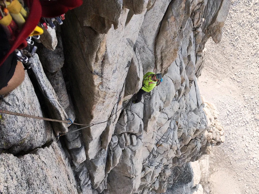
Now the actual climbing. I believe it involves about 800' to get from the base to the summit. Somewhere around 10 pitches to the top. There is actual a pitch ZERO that really should be roped up so that one wasn't even accounted for in the books. It was just the two of us climbing, so all hands are busy. This is always a little rub in these trip reports, no Nat Geo photog on assignment to make us look like certified bad asses. In all honestly, taking photos of each other while actually on route can be quite dangerous, we didn't have much time to ham it up.
The two first pitches were some of the hardest of the climb, at least grade wise. Each pitch held it's own unique obstacles. Pitch 0 was whatever, but 1 and 2 were great cracks. Good rock, interesting moves, don't even think about getting tired.
I took a selfie at an anchor point. I'm not advocating selfies, but I did like how you can see some serious mountain action in the reflection of my sunglasses.
So we are plugging along, and I am spiritually rising to the occasion. While perhaps not climbing my fastest I am confronting any slight notion of fatigue. Dry mouth and altitude really had it's grips on us. There just isn't a to of oxygen getting to your muscles and they feel like molasses.
Taco and I are now at pitch 4, which is actually pitch number 5. This is the crux pitch. It's graded 5.8, which isn't terrible difficult, but you never know. 5.8YDS at Tahquitz or JoshuaTree could kick your ass, you'll find out only on route.
Taco actually loved this pitch. It was a funky one, you had options to stem it, chimney it, off-width technique. Whatever worked, and with a backpack to boot. He said this was his favorite pitch and perhaps the moment of his greatest joy of the day. Good to see the man smile!
He slayed the crux and we had a nice rejoice, I followed and cleaned the gear. Check out that sweet air below. Several hundred feet off the ground now. Here's one of the only couple climbing pics we got. All in safe stances nonetheless.
I wiggled my way up the crux, I would describe it as "soft" for 5.8. The day was getting away from us but we continued on. At the next pitch you have to actually crawl thru this keyhole and pop out the other side to an awkward and uncomfortable, and scary down climb. There are also some massive unavoidable flakes on this route that felt loose. They will not be there forever. When they fall, they will either expose some nice hand and feet holds or perhaps regrade the climb to a harder degree. Only time will tell!
This was a heavy trip, there were many moments when one should be scared shitless, but you don't have time for that. You must focus on the tasks at hand and keep moving. Feelings are sort of extinct during the actual climb. They come before, and after.
Here's another moment I felt safe enough to ask Taco to snap a pic of me.
Because what's the expression "Pics of it didn't happen" ? Ha!
At this stage it was near 4pm. Sun was schedule for around 8pm. Getting to the top of a mountain is only 50% of the trip. You still must get down and then hike back to the car. Most of the day was gone. We climbed to the 6th (actual 7th) pitch according to the map and had to make an intelligent call to retreat.
This was a first try and something of this magnitude so there was no shame or regret. Sure I love summits as much or more than the next, but I value safety more. Taco and I did not want to descent this beast in the dark. Hiking in the dark is one thing, but climbing, no thank you. It was a swift and sure decision. No debating or fantasizing
Taco: "we should go"
Me: "yea we should"
When I got home and decompressed I looked at the maps again, we got so damn close. Here is a free version of the topo from Mountain Project. If you look at the North Arete route and find the little yellow number 6.) about the "5.4 tunnel through" that's about the point where we had to bail. So close!!!!
Taco scouted out a good plan of action to depart and I was able to cross reference it with my cheat sheet. Above the 6th pitch the strategy is to rappel the East face and then descend the North Ridge route. Taco is the man, he has skills to pay the bills and experience. On trips like this you must literally trust your life to your partner. He also has excellent canyoning skills, so he built some quick anchors and down we went.
He seemed to put on a laser focus I just followed his lead. No time for talk, but get the heck out of dodge before the night falls. I've taken some anchor building classes, and it's an art in itself. When you leave gear behind on a retreat, you do the best you can. Two anchors he built had me like WHOA. However Taco rapped em first and didn't die.
This nice little thingy above is webbing tied around a pinched rock, and had me feeling some type of way. He is rapping on the ring to the left, while the blue biner is my personal anchor as I wait to go second. I was a little freaked so I back up my personal with a yellow cam in case he ripped that anchor out. Maybe that cam would have saved us both? Who knows.... redundancy.. yea.
I believe none of this was new to Taco, in fact the proper name for this type of travel is the "Ry-dawg Express" and here is the man himself in the fast lane.
I think it took 5 rappels to get low enough to some rock we could down climb back to Dade Lake. That last anchor wasn't even the wildest one. This one below is like urban legend to rock climbers who don't canyoneer. It's when you tie a stopper knot on the sharp end of a cordelette and then wedge it between a pinched rock. I was trying to find the name of this anchor. It's some crazy shit. I was taught about this in the Advanced Mountaineering Program, but the way it was nonchalantly described felt like "yea it exists but you won't do it."
Well I did, so now I can say I've done that too. Check out the video:
We got down to the ridge. Our final rappel literally ran out every inch of the rope and required rapping of the ends to touch ground. We found a little old climber's booty on the way down, which made up for some we left behind. The world equalizing itself.
We were so happy to get off the mountain before dark. We headed back to Dade Lake to get the rest of our supplies. The talus field back down was so miserable.
We got to our backpacks just as the moon was rising.
We turned back to see the moon pop out above Bear Creek Spire. You son of a bitch.
We had head lamps, and stopped to eat on the way back. It felt like forever to get to the trail head. We got to Gem Lakes and I stole one more amazing photo.
Just hours upon hours of trail work. We got back to the car at 11pm. So it ended up being a 17 hour day with maybe 60-90 minutes of rest. I was a zombie. I passed out inside my car for a miserable 5 hours, woke up cold and drove to Lone Pine. Taco and I pigged out at Alabama Hills Cafe and swapped leads on driving back to the city.
It took me at least 10 days to sort of digest the trip. Part was epic, part was success, part was failure. It's weird in the mountaineering, every time you return home safe it's considered a success. When you fail to reach the summit, we tell each other "it's ok the mountain will be there next time." It only sort of comforts you. So damn close. Part of me feel likes screw that place, but part of me thinks, well I know so much about what to expect now.
Either way, if I went back as a car to car, or if I go back and camp it the night before at Dade Lake, I believe I could summit the North Arete. I spend some serious time on the arete, not thinking about my feelings, but wondering "what the heck am I doing here? Why am I doing this?" I'm not sure I have all the answers. I'm not sure I'm cut out for alpine climbing. However, I know that if there's something that scares you, it might be a good thing to try.